


Leica
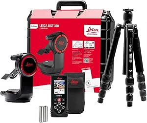
Leica DISTO X4 Laser Distance Meter: Outdoor, Bluetooth, DST 360
★★★★★
IP65-rated, Bluetooth-connected outdoor laser measurement with integrated pointfinder camera and DST 360 compatibility for P2P distance accuracy in direct sunlight.
$109.00*
Check availability
*Price sourced from Amazon.com. Last updated:Jun 27, 2026.Price and availability are subject to change.
Affiliate Disclosure: Studio Supplies may earn a commission from qualifying purchases made through links on this page, at no additional cost to you. This helps support our editorial team.
Notice a mistake? Let Us Know
Overview
Key Features
Data interface for 3D point data with DST 360
Quick distance and area measurements
digital Camera Pointfinder for outdoor
Specifications
Brand
Leica
Model
DISTO X4
ASIN
B07G3KNTNZ
Ingress Protection
IP65
Drop Test Rating
2 meters
Display
Full-color, high-resolution, auto-rotating
Sighting System
Digital pointfinder camera
Tilt Sensor
Yes (Smart Horizontal)
Connectivity
Bluetooth
DST 360 Compatible
Yes (P2P and 3D measurement)
App Support
DISTO Plan App
Pros & Cons
👍 Pros
- IP65 dust and water-jet resistance meets the ingress protection standard required for unsupervised outdoor deployment and construction site use without protective enclosures.
- 2-meter drop test qualification addresses the most common field instrument failure mode — falls from working height during site surveys.
- The digital pointfinder camera solves the primary limitation of laser distance meters in outdoor work: locating the measurement point in ambient daylight without relying solely on a visible laser dot.
- DST 360 compatibility extends the instrument's capability to Point-to-Point measurements and 3D data capture — tasks that require a significantly more expensive total station without this system.
- Bluetooth data transfer to the DISTO Plan App eliminates manual transcription errors and creates a direct digital workflow from field measurement to documentation or CAD.
- On-board tilt sensor enables Smart Horizontal distance calculation without requiring the user to maintain horizontal aim — critical for inclined surface measurement accuracy.
👎 Cons
- Calibration certificate documentation is not a standard included deliverable — procurement for regulated facilities or ISO-compliant QA workflows requiring documented calibration records requires a separate service engagement with Leica Geosystems.
- DST 360 capability requires purchasing the DST 360 adapter set separately — the P2P and 3D measurement modes are not available with the DISTO X4 alone.
- No published measurement range specification is included in the available product description — confirm maximum range in the Leica datasheet before specifying for long-range facility surveys.
- Battery type and expected operational life per charge cycle are not documented in available specifications, complicating procurement planning for extended field deployments.
- The DISTO Plan App dependency for full data workflow introduces a software version and platform compatibility variable that requires ongoing management as mobile OS versions update.
Frequently Asked Questions
What is the measurement accuracy specification of the DISTO X4, and is it NIST-traceable?
Leica publishes measurement accuracy specifications for the DISTO line — confirm the current published tolerance for the X4 in Leica's official datasheet, as accuracy figures are model-revision dependent. For projects requiring documented NIST-traceable calibration, contact Leica Geosystems directly regarding calibration certificate availability, as this is not a standard included item.
What does the IP65 rating mean in practical deployment terms?
IP65 certifies complete dust ingress protection and resistance to low-pressure water jets from any direction. This makes the DISTO X4 suitable for open construction sites, outdoor surveys in light rain, and dusty industrial environments — it is not rated for immersion.
How does the DST 360 adapter enable Point-to-Point measurements, and what does it require?
The DST 360 is a separate smart tripod and adapter set that attaches to the DISTO X4. When combined, the system uses the on-board tilt sensor and the DST 360's angular positioning to calculate horizontal and indirect distances between two points — a measurement mode that is not achievable with a handheld laser meter alone.
What is the Bluetooth range and which platforms does the DISTO Plan App support?
The X4's Bluetooth interface transfers measurements to mobile devices or computers running the DISTO Plan App. Supported platforms and current Bluetooth range specifications should be confirmed in Leica's current product documentation, as app compatibility and firmware support may be updated post-launch.
How does the pointfinder camera function in high-brightness outdoor conditions?
The digital pointfinder camera with full-color, high-resolution display allows the user to aim precisely at the measurement target in bright daylight conditions where a laser dot alone would be difficult to locate visually. The auto-rotating display adjusts orientation for the measurement angle in use, including inclined and overhead surfaces.
Related Products


