

Westcott
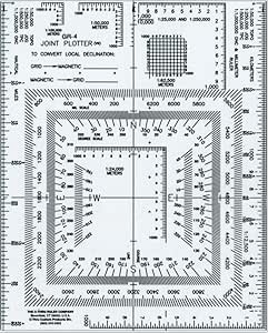
Westcott GR-4 UTM Joint Plotter/Map Reader 5x6"
Precision UTM joint plotter and map reader with 10 metric scales and a full 360-degree protractor for topographic navigation.
$9.05*
View on Amazon
✓ In Stock on Amazon.com
*Price sourced from Amazon.com. Last updated:Aug 28, 2026.Price and availability are subject to change — details.
Affiliate Disclosure: As an Amazon Associate, Studio Supplies earns from qualifying purchases made through links on this page, at no additional cost to you. This helps support our editorial team.
Notice a mistake? Let Us Know
Overview
Key Features
UTM CORNER RULER: Coordinate scale incorporates a full 360 Degree protractor and nautical miles; Ideal for plotting or measuring a GPS position or co-ordinate onto a topographic map
ACCURATE MEASUREMENT: Ruler for quick plotting with metric scales: 1:2400, 1:25000, 1:50000, 1:62500, 1:100000, 1:250000, 1:50000 TOPO, 1:250000 JOG, 1:500000 TPC, and 1:1000000 ONC and millimeter scale
EASY TO READ: Map reader having premium engraved scale and color coding makes plotting easy
MULTI PURPOSE: This transparent scale is ideal for artists, designers, architects, engineers, and students
Specifications
Type
UTM Joint Plotter / Map Reader
Size
5 x 6 inches
Material
Transparent, Laminated
Protractor
Full 360 Degrees
Scales
1:2400, 1:25000, 1:50000, 1:62500, 1:100000, 1:250000, 1:50000 TOPO, 1:250000 JOG, 1:500000 TPC, 1:1000000 ONC, Millimeter
Additional Features
Nautical miles scale, color-coded markings, engraved scales
Brand
Westcott
Frequently Asked Questions
What metric scales are included on this plotter?
The GR-4 includes scales for 1:2400, 1:25000, 1:50000, 1:62500, 1:100000, 1:250000, 1:50000 TOPO, 1:250000 JOG, 1:500000 TPC, and 1:1000000 ONC, plus a millimeter scale.
Can I use this plotter to plot GPS coordinates onto a paper map?
Yes, that is one of its primary functions. The UTM coordinate scale allows you to quickly and accurately plot a GPS position onto any topographic map that uses UTM or metric-based grid systems.
Is this plotter durable enough for field use?
The GR-4 is made from laminated transparent material, which resists moisture and wear better than uncoated paper or cardboard plotters, making it suitable for outdoor and field conditions.
Does the protractor measure both azimuth and bearing?
The integrated 360-degree protractor allows you to measure and plot directions in full-circle azimuth format. Combined with the coordinate scales, it lets you determine both position and direction on a map.
What are the physical dimensions of this plotter?
The GR-4 measures 5 inches by 6 inches, making it compact enough to carry in a map case, cargo pocket, or notebook without adding bulk.
Related Products


